The Narrows may be the most popular hike in Zion National Park. Known for its canyoneering, Zion isn’t exactly as famous as other Western parks as a hiking destination, but maybe it should be.
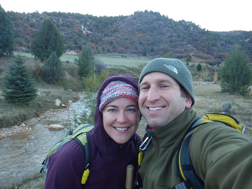
Years ago we saw pictures of the Narrows and put it on our “bucket list”. Some day, some how, it would be cool. So when we found ourselves with a companion pass on Southwest earlier this year (more on that in an upcoming post!) we decided to take advantage of the tickets and planned our trip to Utah.
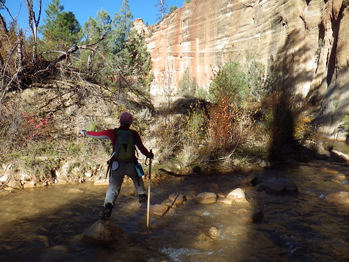
The Narrows is a 16 mile stretch of the Virgin River which over millions of years has cut through a canyon leaving a gorgeous, yet destructive path in it’s wake. Hiking the Narrows requires Canyon shoes, a good hiking stick and some pretty good information, especially in the summer when flash floods are not– ahem- rare in these canyons. Fortunately by October, the risk of flash flood is significantly reduced (yay for cold weather). Don’t get too excited, the air and water temp are equally cold. We planned to hike in full dry suits, only to see the weather warm up a few days before we arrived. With water levels low (it never came above our thighs), we opted instead for dry pants lined with long undies and plenty of layers on top.
The start of the 16 mile hike through the Narrows is deceptively wide. From the drop off point at Chamberlain’s Ranch the first few miles are easy hiking through pastures and cattle fields. We followed the river for about 2 hours before we had to get our feet wet, something we were thankful for given that it was a frosty 35 degrees F at the trail head.
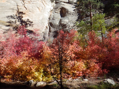
By mid morning we started to enter the canyon, wide at first and lined with gigantic Ponderosa Pine trees. Most breathtaking for us weren’t the canyon walls, but the incredible colors of the leaves at that altitude. As we dropped in elevation, the colors became more muted and eventually morphed completely into green, but at the top of the canyon the bright oranges and reds looked like a vibrant fire spreading through the canyon.
Thankfully, because the water level was so low, we were able to avoid any deep water, and easily catch all the cut arounds (there is a 13 foot waterfall around mile 7) and have a relatively easy time of it. Although low water also meant less of a chance of being swept away, we were thankful to have hiking poles to test the depth and footing, especially around river bends. By the time we hit the confluence of Deep Creek (halfway through the hike), we were happily hiking with our eyes pinned up at the canyon walls.

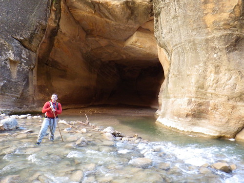
As we continued the hike, the canyon became more and more narrow and the scenery more and more spectacular. The trees gave way to short river grass. We didn’t see another soul on the hike after the trail head until we reached Big Springs (the northernmost point for day hikers starting at the southernmost end of the canyon). Wall Street, one of the most famous stretches of the canyon appeared blue in the hazy late afternoon sun. By the time we arrived at the take out at Temple Sinawava, we were tired, wet and feeling rather accomplished.
All in all it was 16 miles in a river over 10 hours. That’s pretty darn fast, not thanks so much to our ability, but thanks to the low water level and lack of a crowd. No matter what time of year you go, I can’t stress enough how important it is to respect nature and be prepared. Two days after our hike I overheard a meeting about a rescue operation in the Narrows to take out someone with a suspected femoral fracture. Extraction from a canyon is never easy, but add to it water, cold overnight temperatures and winter sun and you’ve got a recipe for disaster. You may want to check out our Postcard from the Narrows for more pictures of our hike.
Hiking Notes: You obviously need a permit to hike the Narrows from top to bottom, even if you are planning on two days. The Park Service gives 40 permits per day, which can be reserved online and picked up at the Wilderness Desk in the Visitor’s Center. We rented shoes, booties and walking sticks from a company in town. As with all rentals, check the condition and fit of your gear before you leave the shop. We also bought a shuttle ride(about $35 per person) from a company in town from the Visitor’s Center to Chamberlain’s Ranch. It was about a 1.5 hr drive. With a 4-wheel drive vehicle you can run shuttle yourself, something that we just weren’t interested in. There are 12 campsites in the canyon, all beyond the half way point, some of which are easy to miss. You should reserve a campsite in advance and bring a stove, no open fires are permitted in the canyon.
The water level in the canyon can obviously make a huge difference in your experience during the hike, so it is important to check the water levels in the days leading up to your hike. You can check the water gauge for the North Fork of the Virgin River online by clicking here. High water not only slows you down, but makes the hike much, much more dangerous. No matter the water level, you should be properly outfitted and prepared. The water in October was cold and had the level been higher, we would have had a difficult time staying warm for so long.


Recent Comments