• Home
  • About
    • Who We are
    • Affiliates
    • Disclosures & Guidelines
    • FAQs
    • Privacy Notice
  • Funding Your Travels
    • Banking on the Road
    • Credit Cards in Our Wallet
    • Spending
  • Contact
    • Media
    • Submission Guidelines
    • Partnership Opportunities

i should log off

log off and live!

  • Travel & Planning
    • Travel Reflections
      • Good, Bad & Ugly
      • Re-Entry
    • Travel Resources
      • Travel Tips
      • Travel Bloggers
    • Reviews
      • Gear
      • Operators
      • Travel Clothing
    • Travel Gear
      • Cameras
      • Danny’s Clothes
      • Electronics
      • Health & Hygiene
      • Jillian’s Clothes
      • General Gear
  • Destinations
    • Travel Guides
    • Africa
      • Egypt
      • Ethiopia
      • Lesotho
      • Kenya
      • Malawi
      • Morocco
      • Mozambique
      • Namibia
      • South Africa
      • Sudan
      • Swaziland
      • Tanzania
      • Uganda
      • Zimbabwe
    • Asia & Oceania
      • Armenia
      • Cambodia
      • China
      • Georgia
      • India
      • Kazakhstan
      • Laos
      • Thailand
      • Turkey
      • Uzbekistan
      • Vietnam
    • Caribbean
      • Antigua
      • Cuba
      • Jamaica
    • Central America
      • Belize
      • Costa Rica
      • Guatemala
      • Honduras
      • Nicaragua
      • Panama
    • Europe
      • Armenia
      • Austria
      • Belgium
      • Czech Republic
      • France
      • Georgia
      • Germany
      • Hungary
      • Italy
      • Spain
      • Turkey
    • North America
      • Canada
      • Mexico
      • USA
    • Middle East
      • Egypt
      • Israel
      • Jordan
      • Oman
      • Turkey
    • South America
      • Argentina
      • Brazil
      • Bolivia
      • Chile
      • Colombia
      • Ecuador
      • Peru
      • Uruguay
  • Weekend Adventures
    • Cycle
      • Pastimes
        • Beer & Wine
        • Books
        • Cooking
        • History & Culture
    • Dive & Snorkel
    • Hike
    • Trek
    • Whitewater
  • Photos
    • Photo of the Day
  • Family Travel
You are here: Home / Archives for hiking

A Really Really Really Really Long Walk

April 12, 2013 By Danny

I once walked 100 kilometers in one day. We started at 3am, the four of us. It was an organized event so we weren’t alone but when I walked up to the finish line at midnight I had been alone for hours.

Somehow, I thought it would be a good idea to do that long walk again….in winter!

What started out as a simple dare quickly grew into a quest for myself and three other friends. (This was a different group from my first foray in long distance walking.) I had been hoping to rejoin the 100km walk again later this month but scheduling kept that from happening. In the process I heard about a 50 mile trek to commemorate the first time this walk was done, by Robert F. Kennedy, mentioned to my friends, and there was no turning back.

The group who started the 50mi Kennedy Walk
At the start there were 34 walkers. Only 12 would walk the entire distance.

Because this was was shorter, the start time was a leisurely 4am. In preparing for the walk, all I could think about was the immense pain and suffering I felt toward the end of the 62mi when I’d done it the first time. Yes, this was was shorter, but it was winter time so really no real benefit from the decreased distance. I’d walk a little less but have to deal with temperature control, freezing water and maybe even snow on the trail.

We got to the trailhead a bit late but still managed to start with the group. It was dark. It was cold. I wanted to walk faster than the rest of my group. We all wanted to sleep. The sun came up. We ate food. My water froze. I unfroze my Camelback’s hose so I could drink. It froze again. Fun, right?

The Towpath connects Washington, DC to Cumberland, MD
A lot of the path looked just like this. It was a beautiful day….in February!

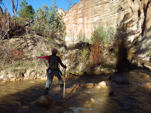
The walk itself took place along the C&O Canal. The Canal was built alongside the Potomac River to ferry goods up and down river between Washington, DC and Cumberland, MD; a distance of about 185mi. The walk I did before, the 100km, started in DC itself and went all the way to Harper’s Ferry, WV. The “shorter” walk I did the second time started further upstream in Great Falls, following the same canal and towpath all the way to Harper’s Ferry.

Chester and Lionel on the trail, with a bow tie!
You can see Chester’s bow tie…I tied it!

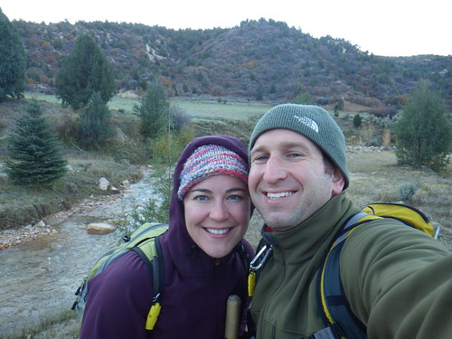
Eventually we all hit our stride and began to enjoy our day despite the cold. This is probably a good point to introduce the rest of my cohorts. There was Chester and his lovely bride Catherine. Chester and I knew each other from GWU where we played Rugby with the fourth member of our trip, Lionel. Lionel and Catherine, who for various reasons didn’t want to walk the whole way, each took turns shuttling the car while Chester and I walked the full distance. We were all dared to start the day wearing oxford shirts and bow ties (my bowtie fell off before our first pit stop) to help us commemorate RFK but Chester was the only one stupid strong enough to make the whole trip in a pair of Cole Haan dress shoes.

The walk itself is easy.  Technically, it is uphill, but 600 feet in elevation spread over 50 miles doesn’t really count for much elevation.  It’s that very flatness that causes the pain in the hip flexors and ankles, from doing the same thing over and over again for hours.  With the sun up, we warmed up quite a bit and I didn’t have any more problems with water freezing.  We walked some more and some more.  We talked politics and business and philosophy, as friends do, and then we talked about how much we hurt and what we wanted to eat.  A friend visited us a few hours before sunset and brought us hot chocolate and magic bars.  Amazing.  We kept walking.  Walking some more.  Did I mention this was a very long walk?  We saw some kind of strange albino deer. The sun set.  The temperature dropped a lot.  We still had miles to go. We kept walking.

In the end we didn’t finish too long after sunset, arriving at Harper’s Ferry right about 7pm.  Although 7pm sounds like a nice time to finish something, we’d been walking for 15 hours straight and were simply exhausted.  For me though, I was shocked at how much easier a 50 mile walk was compared to a 62 mile walk, and thankful that we’d not encountered any snow. When I’d finished this walk the first time, doing the full 100km, I could barely move.  Although I was plenty sore this time around things like stairs and hills didn’t look quite so scary.  We even went out for dinner and each enjoyed a nice pint of beer.

2013-02-09_20-42-24_427

Then we got to the B&B we’d booked for the night, and Chester removed those Cole Haans…  The shoes survived surprisingly well but the feet were another story.

   2013-02-09_20-43-41_307

Filed Under: Featured, Headline, Hike, photos, USA, Weekend Warrior Tagged With: harper's ferry, hiking, rfk, rivers, sore feet, walk, washington

Inside Zion Canyon’s Narrows

November 28, 2012 By Jillian

The Narrows may be the most popular hike in Zion National Park.  Known for its canyoneering, Zion isn’t exactly as famous as other Western parks as a hiking destination, but maybe it should be.

Years ago we saw pictures of the Narrows and put it on our “bucket list”.  Some day, some how, it would be cool.  So when we found ourselves with a companion pass on Southwest earlier this year (more on that in an upcoming post!) we decided to take advantage of the tickets and planned our trip to Utah.

The Narrows is a 16 mile stretch of the Virgin River which over millions of years has cut through a canyon leaving a gorgeous, yet destructive path in it’s wake. Hiking the Narrows requires Canyon shoes, a good hiking stick and some pretty good information, especially in the summer when flash floods are not– ahem- rare in these canyons.  Fortunately by October, the risk of flash flood is significantly reduced (yay for cold weather).  Don’t get too excited, the air and water temp are equally cold.  We planned to hike in full dry suits, only to see the weather warm up a few days before we arrived.  With water levels low (it never came above our thighs), we opted instead for dry pants lined with long undies and plenty of layers on top.

IMGP0239
20 seconds before we started

The start of the 16 mile hike through the Narrows is deceptively wide.  From the drop off point at Chamberlain’s Ranch the first few miles are easy hiking through pastures and cattle fields.  We followed the river for about 2 hours before we had to get our feet wet, something we were thankful for given that it was a frosty 35 degrees F at the trail head.

IMGP0247

By mid morning we started to enter the canyon, wide at first and lined with gigantic Ponderosa Pine trees. Most breathtaking for us weren’t the canyon walls, but the incredible colors of the leaves at that altitude. As we dropped in elevation, the colors became more muted and eventually morphed completely into green, but at the top of the canyon the bright oranges and reds looked like a vibrant fire spreading through the canyon.

IMGP0256

Thankfully, because the water level was so low, we were able to avoid any deep water, and easily catch all the cut arounds (there is a 13 foot waterfall around mile 7) and have a relatively easy time of it.  Although low water also meant less of a chance of being swept away, we were thankful to have hiking poles to test the depth and footing, especially around river bends. By the time we hit the confluence of Deep Creek (halfway through the hike), we were happily hiking with our eyes pinned up at the canyon walls.

As we continued the hike, the canyon became more and more narrow and the scenery more and more spectacular.  The trees gave way to short river grass. We didn’t see another soul on the hike after the trail head until we reached Big Springs (the northernmost point for day hikers starting at the southernmost end of the canyon).  Wall Street, one of the most famous stretches of the canyon appeared blue in the hazy late afternoon sun.  By the time we arrived at the take out at Temple Sinawava, we were tired, wet and feeling rather accomplished.

IMGP0305

All in all it was 16 miles in a river over 10 hours. That’s pretty darn fast, not thanks so much to our ability, but thanks to the low water level and lack of a crowd. No matter what time of year you go, I can’t stress enough how important it is to respect nature and be prepared. Two days after our hike I overheard a meeting about a rescue operation in the Narrows to take out someone with a suspected femoral fracture. Extraction from a canyon is never easy, but add to it water, cold overnight temperatures and winter sun and you’ve got a recipe for disaster. You may want to check out our Postcard from the Narrows for more pictures of our hike.

Hiking Notes: You obviously need a permit to hike the Narrows from top to bottom, even if you are planning on two days. The Park Service gives 40 permits per day, which can be reserved online and picked up at the Wilderness Desk in the Visitor’s Center. We rented shoes, booties and walking sticks from a company in town. As with all rentals, check the condition and fit of your gear before you leave the shop. We also bought a shuttle ride(about $35 per person) from a company in town from the Visitor’s Center to Chamberlain’s Ranch. It was about a 1.5 hr drive. With a 4-wheel drive vehicle you can run shuttle yourself, something that we just weren’t interested in.  There are 12 campsites in the canyon, all beyond the half way point, some of which are easy to miss.  You should reserve a campsite in advance and bring a stove, no open fires are permitted in the canyon.

The water level in the canyon can obviously make a huge difference in your experience during the hike, so it is important to check the water levels in the days leading up to your hike. You can check the water gauge for the North Fork of the Virgin River online by clicking here.  High water not only slows you down, but makes the hike much, much more dangerous.  No matter the water level, you should be properly outfitted and prepared.  The water in October was cold and had the level been higher, we would have had a difficult time staying warm for so long.

Filed Under: Destinations, Headline, North America, USA Tagged With: hiking, national parks, zion canyon

Postcard from The Narrows

October 31, 2012 By Jillian

We spent an amazing week inside the canyons of Zion National Park camping, hiking and exploring the canyons.  Although we’re still trying to get our head around all of it, here’s a sneak peak of our 16 mile hike inside the Narrows.  51 degree water, gorgeous fall colors and 10 hours of hiking, what more could we ask for?


IMGP0340
IMGP0333

IMGP0326

IMGP0320

IMGP0289

IMGP0285

IMGP0270

IMGP0274

IMGP0257

IMGP0267

Filed Under: Destinations, Headline, North America, USA Tagged With: hiking, national parks, Zion National Parks

A Weekend in the Berkshires

September 5, 2012 By Jillian

As Floridians who prefer the mountains over the beach, you may say that we live in the wrong place.  That’s ok , just as long as we get to spend our weekends and holidays in the mountains. This past weekend we were lucky enough to have a real mountain get away thanks to some friends who decided to get married in the bride’s home town in the Berkshires (Western Massachusetts).  A landscape that inspired Thoreau and Emerson,  and a weekend of hiking, eating and friends, what could be better?

The Berkshires is a popular mountain retreat area for the city dwellers of the Northeast.  With incredible landscapes hiking, fun and lively small towns and hospitable people, who can blame them for retreating to these woods?  Here’s what we suggest if you have a long weekend to spend in the Berkshires.

Day 1.  The Berkshires are a 2.5/3 hour drive from either New York City or Boston so take an easy morning and get to the mountains slowly.  Then spend the afternoon exploring some of the neat museums and towns in the area.  The Norman Rockwell Museum in Stockbridge is worth a few hours, but there are plenty of Gilded Age Mansions in the area that are open to the public if you are looking for something a bit more architectural.

Day 2. Start your morning with some delicious delicacy’s from a local bakery.   Great Barrington has a host of little coffee shops and delicious cafes, as do most of the other smaller towns along the way.  Saturdays are a great day to check out a local co-op or farmer’s market, especially if you are going to head up a mountain. Spend the afternoon hiking Mt. Greylock or Mt. Everett, two popular peaks in the area along the famed Appalachian Trail.  If you’re looking for something a bit less strenuous, or with less elevation, the area is covered in State Parks, like Mt. Washington and Beartown which have a variety of trails.  End your day relaxing at Great Barrington Brewery where you can enjoy solar brewed beers like Black Bear Stout and Berkshire Blond. If you arrive in summer, you may be lucky enough to grab lawn seats at Tanglewood, an outdoor music venue.  Pack a picnic and relax under the starts to performers like James Talyor and Evanessance.

Day 3. Time for some adventure! Cycling is a popular activity in the Berkshires and really if you don’t want to be outdoors, you probably shouldn’t be in the mountains. You can rent a bike in the larger towns like Adams, Great Barrington, Lenox or Pittsfield or jump on a day long cycling tour with a local operator.   The area is also home to ziplining courses, horseback riding, mountain biking trails and even ATV trails.  Choose the adventure of your fancy and make a day out of it!

IF YOU GO:  It’s helpful to have a car to explore some of the smaller towns and villages that make the Berkshire’s so special.   Take a few trips outside the car to explore the downtown areas and local shops, remember life in the mountains is about enjoying your surroundings. Save yourself from the mundane and skip staying at one of the chain hotels that seem out of place in the area.  Instead, stay at something with a bit more character like a B&B or a rental apartment.Rental apartments are popular in the area and give visitors a taste of mountain living, sometimes in funky places like converted barns or centuries old homes.


Filed Under: Destinations, Headline, North America, USA Tagged With: berkshires, hiking, mountains

Hiking in Egypt

July 6, 2012 By Jillian

Hiking in Egypt’s Sinai desert is more fun than you think.  Surely desert hiking requires a bit of preparation, but the Bedoin’s have it down to a science. From small kiosks along the hiking route up Mt. Sinai to a bevy of guides willing to help you from town, they’ve perfected the art of hiking with ease.

Mount Sinai (2285m ) is the most famous and probably most sacred mountain in Egypt.  Pilgrims from all over the world converge on the mountain, usually late at night to be on the summit for sunrise.  We chose to do the exact opposite, and hike up to the summit for sunset.  It turned out to be fantastic, as the sunset reflected on the rocks was a sight to be seen.  Read more about our hike up Mt. Sinai.

While we made it up on our own two feet, there are plenty of people who make it to the top and are too tired to come down.  Hence this guy trekking up on a camel.  Huts along the path provide every kind of nourishment and comfort you can imagine, but still some find the path too difficult to navigate and the Bedoin’s are more than happy to provide transportation up or back.

Mt Sinai in Egypt

HIKING IN EGYPT

IF YOU GO: Hiking in Egypt does require a bit of pre-planning, even with the bevy of help from the local Bedoin’s.  It is still a desert, so sun protection is a must, as is adequate water.  You can imagine how expensive a bottle of water can be at the top of a mountain in the desert.  In addition to hiking Mt. Sinai, you can also climb Mt. Catherine (also leaves from St. Catherine), Egypt’s tallest mountain.  St. Catherine is easily accessible if you travel to Sharm el Sheikh first, as there are tour buses that leave every day.  From Cairo, you will likely have to change transportation in Dahab although there are a few buses direct to St. Catherine every day.  We have an independent traveler’s guide to Egypt that you might find valuable if you’re traveling in the area.


Filed Under: Egypt, Middle East, photos Tagged With: hiking, sinai

  • « Previous Page
  • 1
  • 2
  • 3
  • 4
  • …
  • 13
  • Next Page »

Connect With Us

  • Email
  • Facebook
  • Flickr
  • Pinterest
  • RSS
  • Twitter

Featured Posts

Our Bucket List
How We Travel For Free
$ Travel Tips

Recent Comments

  • Barbara on Kayaking Kauai’s Na Pali Coast
  • Lori Hubbard on Review: Eneloop Batteries and Charger
  • TK on The Trouble with Philadelphia

Banking on the Road

It can be very hard to keep track of your finances while you're on the road long-term. Be sure to check out how we took care of our finances while traveling and feel free to email us any questions you have.

Adventure Guides

Torres Del Paine
China Adventure
Uzbekistan Overland
Egyptian Odyssey
Malaria
Argentina Adventure
DIY African Safari
South Africa Guide
Bolivia by Bus
How-To African Visas

[footer_backtotop]

Copyright 2008-2015 · All Rights Reserved · Contact I Should Log Off · RSS · Partner With Us · Privacy